History of the project
The ILCA / ODEM Project
The
International
Livestock
Center
for
Africa
ILCA/CIPEA
was
created
in
1975,
as
the
13
th
research
center
of
the
Consultative
Group
on
International
Agricultural
Research
–
CGIAR
–
which
funded
research
centers
promoting
the
"green
revolution".
It
established
itself
in
Mali
in
1979,
in
collaboration
with
the
Institute
of
Rural
Economy,
IER.
In
association
with
the
Operation
for
Livestock
Development
in
the
Mopti
Region
–
ODEM
–
and
funded
by
the
World
Bank,
the
CIPEA-IER/ODEM
teams
started
a
very
ambitious
research
and
development
project
which,
in
the
productivist
approach
in
fashion
at
that
time,
was
aimed
at
'modernizing'
livestock
breeding
in
the
5
th
region
of
Mali
in
order
to
make
the
region a pole of animal production in the area.
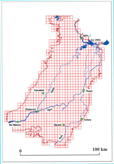
Our mandate was threefold:
•
To
conduct
a
fine-scale
study
of
the
rangelands
of
the
Inner
Delta
of
Niger
(fig
1),
as
well
as
transhumance
during
the
rainy
season
and
cool
dry
season
on
the
left
bank,
reaching
westwards
to
the
Serpent
valley
and
northwards
up
to
the
Mauritanian border.
•
To
conduct
a
study
of
the
pastoral
organization
of
the
land
(territories,
transhumance
paths
...),
and
of
conflicts
between
pastoralists,
fishermen
and
farmers related to the uses of natural resources.
•
To formulate proposals for the development of livestock productivity.
The
means
at
our
disposal
were
exceptional:
a
budget
of
more
than
one
million
dollars,
a
fleet
of
vehicles,
a
twin-engine
aircraft,
a 1:50 000 photographic coverage in Infrared Color, commissioned to the French National Geographic Institute, IGN.
The
human
resources
were
equally
considerable:
some
thirty
Malian
and
international
researchers
and
collaborators
divided
into
several teams:
•
A team of ecologists under the direction of Pierre Hiernaux, Mohamed Idrissa Cissé and Lassine Diarra.
•
A
team
responsible
for
studies
and
for
the
mapping
of
pastoral
land
tenure
under
the
direction
of
Salmana
Cissé,
Samba
Soumaré and Jérôme Marie.
•
An team for aerial surveys (including cattle counting) under the direction of Kevin Milligan, David Bourn and William Wint.
•
A
team
responsible
for
the
study
and
implementation
of
a
reform
of
territories
and
uses
that
regulate
access
to
natural
resources.
This work was directed by Salmana Cissé, Alain Rochegude (a lawyer) and Jérôme Marie.
•
Finally,
a
team
based
at
ILCA
headquarters
in
Addis
Ababa,
in
charge
of
mapping.
Mark
Haywood,
his
director,
made
several
visits
to
the
fields
with
Pierre
Hiernaux.
He
realized
the
whole
photo-interpretation,
defined
and
coordinated
the
drawing
of
the
cartographic
system.
Land
tenure
crews
charged
with
registering
the
leyde
boundaries,
pastoral
trails,
and
resting
camps
worked
directly on the 1:50 000 topographic background maps developed by Mark Haywood.
This
resulted
in
a
report
entitled
"Seeking
a
solution
to
the
problems
of
animal
husbandry
in
the
Inner
Delta
of
the
Niger
in
Mali",
written
by
Jérôme
Marie
and
submited
to
the
Government
of
Mali
and
the
ODEM
in
March
1983.
The
five
volumes
(1100
pages)
dealt with :
1
.
Rangelands in the study area (their floristic composition, ecological conditions, production, etc.)
2
.
The distribution and density of livestock in different seasons obtained by systematic aerial surveys.
3
.
Geographical
and
socio-economic
monographs
covering
all
the
leyde
(Fulani
pastoral
territories
in
the
Delta),
dealing
with
villages, population, the organization of transhumance, land conflicts, etc.
4
.
A
legal
analysis
proposing
solutions
to
solve
conflicts
between
pastoralists,
fishermen
and
farmers.
In
particular,
we
advocated
the
replacement
of
leyde
by
agro-pastoral
units,
territorial
communities
headed
by
an
elected
council
whose
competence
would
be to regulate the use of resources (land, water, pastures, etc.) among the various holders of rights.
These reports were accompanied by detailed maps in three layers:
•
The
maps
of
the
Niger
Inland
Delta
rangelands
(27
maps
at
1:50
000
scale
in
80x50
cm
format).
But
also
the
map
of
the
rangelands
of
the
'Delta
mort'
and
the
Office
du
Niger
(31
maps
in
the
1:
100
000
format
40x28cm)
and
the
maps
of
the
continental rangelands to the West and North (6 IGN topographic maps 1: 200,000).
•
Pastoral
land
mapping
of
the
Inland
Delta
of
the
Niger
covering
the
31
leyde
(Fulani
pastoral
territories)
of
the
Delta.
This
cover,
rigorously
superimposable
to
the
previous
one,
bore
the
detailed
hydrographic
network,
the
relief
elements
(hills
or
"togge"
),
the
villages
and
hamlets
cultivated,
the
pastoral
tracks
inside
the
Delta
(over
3,600
km)
pastoral
gîtes
(over
1,000),
toponymy,
land
disputes over lodges, trails or
leyde
boundaries.
•
Maps
of
agricultural
land
use,
comparing
1952
and
1974/75
(Haywood
M.
1981.
"Evolution
of
land
use
and
vegetation
in
the
Sudano-Sahelian zone of the ILCA project in Mali", Doc. Working Group 3, ILCA, Addis Ababa, 187 p.).
This work was not implemented and its results were never published, for several reasons:
•
Putting
it
into
practice
presupposed
that
relations
between
the
populations
and
the
administrations
concerned
could
be
established
on
a
decentralized
and
democratic
basis.
We
advocated
local
management
of
natural
resources
and
land
on
an
elected
democratic
basis.
Despite
the
success
of
the
two
experimental
units
that
we
had
been
authorized
to
create,
the
Malian
political
power
was
not
ready,
in
1983,
for
such
a
radical
reform.
The
decentralization
put
in
place
under
the
Third
Republic,
which
led
in
1999
to
the
creation
of
rural
communes
and
the
election
of
municipal
councils,
could
have
offered
more
favorable
political
conditions
for
the
local
management
of
natural
resources
as
we
advocated
at
the
time.
Perhaps
because
the
reform
has
not
been
pushed
far
enough
or
because
the
government
was
unable
or
unwilling
to
resolve
the
serious
problems
of
corruption
affecting
the
Inner
Delta,
the
land
conflicts
that
overwhelm
the
populations
of
the
Delta
have
multiplied;
undoubtedly,
this
situation
is
not
unrelated
to
the
emergence
of Islamic terrorism, the insecurity and the civil war that affect this beautiful region.
•
ILCA/
CIPEA
had
committed
itself
to
the
study
only
as
a
result
of
being
urged
to
do
so
by
the
World
Bank.
It
had
not
budgeted
for
any
publication
other
than
the
delivery
of
the
documents
and
maps
under
contract
to
the
ODEM
project.
Publications
were
alien
to
the
CIPEA's
policy
of
the
time,
which
focused
on
projects
for
the
development
of
animal
production.
Concern
about
pastoral
land
was largely misunderstood by my supervisor at the time, a dairy engineer!
•
But
a
third,
equally
important
reason
for
the
absence
of
publication,
came
from
our
inability
to
carry
out
syntheses,
modelling
and
operations
dedicated
to
spatial
analysis
on
such
a
mass
of
data
in
the
absence
of
a
powerful
computing
tool.
In
1983,
IT
used
heavy,
slow,
and
expensive
systems.
GIS
was
practically
non-existent
and
remote
sensing
was
only
beginning
(SPOT,
for
example,
had
not
yet
been
launched).
Pierre
Hiernaux
processed
his
phyto-ecological
observations
with
the
help
of
punched
cards;
when,
in
1983,
Mark
Haywood
wanted
to
quantify
the
surface
area
of
‘bourgoutières’
(one
specific
plant
formation
out
of
120,
composed
of
837
plots
-
out
of
a
total
of
14,535),
he
had
to
cut
out
the
837
plots
representing
this
plant
formation,
then
weigh
the
paper
to
deduce
the surface area!
The creation of the Geographic Information System DELMASIG
However,
the
project
archives
were
carefully
kept,
and
in
the
early
1990s,
with
the
authorization
of
ILCA
–
which
was
not
interested
in
the
study
anymore
–
a
first
attempt
was
made
to
publish
the
maps
with
the
active
help
of
colleagues
of
the
Institute
of
Livestock
and
Veterinary
Medicine
for
the
Tropics,
IEMVT
(now
a
department
of
Center
for
International
Cooperation
in
Agronomical
Research
toward
Development,
CIRAD).
The
exorbitant
cost
of
this
publication
(about
1
million
francs
or
170,000
euros)
caused
the
project
to
fail.
It
became
evident
that
only
the
realization
of
a
GIS
would
make
these
data
accessible
and
provide
the
syntheses
that
we
had
not
been
able
to
carry
out
at
the
time.
Starting
in
1997,
thanks
to
François
Cuq’s
friendly
help,
Jérôme
Marie,
the
team's
geographer,
was
able
to
work
full-time
at
the
Géosystèmes
laboratory
of
the
CNRS
on
Arc
Info
software
in
order
to
model
the
data
collected.
A
small
team
was
set
up
with
Pierre
Hiernaux,
Mark
Haywood
(who
digitized
all
the
rangeland
maps),
Isabelle
Louise
Bisson,
a
student
and
database
specialist,
Emmanuel
and
Jacqueline
Giraudet,
CNRS
engineers,
Alain
Trouvé,
a
mathematician
in Paris13 -Villetaneuse and Yu Yong, a computer scientist of the University of Shanghai then registered for a post-doc in Paris 13.
The original project was enriched with new data:
Water levels up to 2015, in order to model flooded areas.
The
areas
cultivated
in
1952,
1975,
1989,
2015,
in
order
to
relate
rice
cultivation
with
plant
formations,
types
of
soil,
and
flood conditions, which makes it possible to analyze the strategies of rice farmers.
The new territorial organization of Mali, in order to situate our analyses in the context of the new rural communes.
Landsat
satellite
(since
1984)
and
then
Sentinel
images,
which
make
it
possible
to
modelize
the
surfaces
with
flood-related
each
year.
Comparing
the
analyses
of
the
satellite
images
with
our
own
model
of
the
flooded
areas
for
each
flood
height
makes
it
possible
to
clarify
their
validity.
The
model
has
also
been
enriched
by
thousands
of
altitude
ratings
(accurate
to
the
cm)
and
created
by
IGN
on
the
occasion
of
the
creation
of
the
Mathematical
Model
of
the
Niger
River
in
the
1980s.
These
data now pave the way for the realization of a Digital Terrain Model. (see page 23)
In
2014,
Pierre
Hiernaux
and
Matthew
D.
Turner
were
able
to
return
to
the
field,
revisit
the
sites
described
between
1979
and
1983,
and
thus
document
the
dynamics
of
the
vegetation
in
view
of
a
possible
update
of
the
vegetation
map.
This
gave
rise
to a publication in 2021. (see bibliographies)
It
is
therefore
the
evolution
of
this
GIS
now
developed
under
ARC
GIS
and
called
"DELMASIG"
–
for
SIG
DELTA
inside
MALI
–
that
Jérôme
Marie
and
Pierre
Hiernaux
have
decided
to
make
accessible
to
the
scientific
community
by
creating a dedicated website with these data and maps.
ILCA-IER / ODEM Project staff
•
Pierre Hiernaux, Mohamed Idrissa Cissé and Lassine Diarra for the rangeland studies.
•
Kevin Milligan, David Bourn, William Wint, Peter N. De Leeuw and Mamadou Keita for the aerial surveys.
•
Abdallah
Ben
Alakaouri,
Salmana
Cissé,
Jérôme
Marie,
Mamadou
Nadio,
Alain
Rochegude,
Samba
Soumaré
and
Ibrahim
Ag
Youssouf
for
ILCA-IER,
Kader
Cissé,
Mahamet
Keita,
Yahia
Maguiraga,
Gaoussou
Sidibé
for
the
ODEM
under
the
direction
of
Dr. Nouhmou Diakité, for the socio-economic and legal study.
•
Mark Haywood and his team for photo interpretation and mapping.


Study area with the UTM 30 grid (5000 m.)